

Locks: 0; TTT: 3:55 hrs)
Notice how the speed has gone up almost 2 mph. That is the current of the Mississippi greater than the current of the Illinois river. The trip was uneventful until we got to the lock. There on the outside of the lock wall where others have docked, was three barges from the US Corps of Engineers. The lock master said that there was room in front and some room in behind the barges closer to the dam. The two big boats took the easy access and Linda and I went around to the back. It was a good quiet spot, so quiet that no one helped us dock.
Headquarters and Toucan tried the first wall but found that it was too shallow there so they came over to our spot. There was only room for one other boat on the wall so Toucan rafted to Headquarters for the night.
Sorry we have no photos from the lock wall; an oversight.
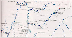
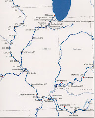
The next morning was rather interesting as we needed an early start for the long journey. The wind had come up enough to make it difficult to get out of our hole behind the barges. We eventually managed and headed for the Ohio River over 100 miles away.
(Friday Sept 14 - Dist: 136.6 mi; Avg Speed: 11.5 mph;
Locks: 0; TTT: 11:35 hrs)

 One of the highlights in our long day of travel was passing an old Mississippi river boat. It has 350 staterooms and is plying the river like in the old days.
I still cannot believe how low the water level is on the river. Here are a few shots that those who travelled with us in 2010, will not recognize.


Cape Girardeau is another town along the river that has built a flood wall. Seems impossible that the water could rise that high.

Well we managed to reach Lock #53 before dark and got comfortably anchored for the evening. A nice quiet BBQ on Q's End and we were all ready for bed.


No comments:
Post a Comment