The Mighty Mississippi ????
(Wednesday Sept 12 - Dist: 60.7 mi; Avg Speed: 8.0 mph;
Locks: 2; LWT: 2 Hrs; TTT: 8:30 hrs)
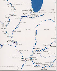
T’was a fine day for travelling. The first little bit of the Mississippi River has cliffs on one side and the flats, a flood plain, on the other. Everything was fine until we arrived at Lock # 27, Chain of Rocks Lock. The main chamber was unserviceable because someone hit something and may have damaged a valve and there was a tow stuck trying to get into the auxiliary chamber. They must have raised the water level a bit in our pool because he finally got in after about an hour… then he was hard aground trying to get out of the lock. There was even another tug there and they took about another hour to free him. There was no raising the pool on the down side because there are no more dams on the Mississippi River; free sailing right to New Orleans.


After the 2 hour delay we carried on and soon went by St. Louis. Other than the Arch we could not see much. There is a concrete wall along the river to keep high water out of the city and we were very low. In fact Fern at Hoppies says the river is about 14 feet below normal for this time of year. The water level has even dropped a further foot each of the last 2 days. I do not understand why the city of St. Louis does not have any marinas whatsoever. True there is a ton of barge traffic and commercial docks but one would think that you could fit in at least one marina. Oh well, we dodged all of the tows and the barges which were anchored in the river and made it to Hoppies by 4 PM.
The Mississippi River is a totally different river than 2 years previous. There are very few places where the water is turbulent and swirling and one can see all of the wing dams. Docking at Hoppies was a non event this time.All Linda and I could remember about our first visit here was the three attempts that The Old Grouch needed to dock at the barges.
This year it wasn’t exciting at all; actually fairly normal. Then I looked around. The wing dam just below Hoppies was a non issue the first time because I drove over it when we docked in 2010. The water was right up to the edge of the river bank so you can see how dramatic the difference is in just the 2 years.
With the low water levels we have been forced to move on because another 6 boats are expected to arrive today and they need our spots on the barge. Fortunately, the next stop, our only choice, is just 42 miles away so we wereable to go in and visit the pretty town of Kimmswick and eat lunch at the famous Blue Owl restaurant.
Off to Kaskaskia Lock and Dam.


No comments:
Post a Comment